Back to the Peninsula... by Kevin Hatcher

A few weekends ago the weather report suggested that it would be amazing blue skies and warm. So we decided to go back up to Snæfellsnes peninsula for some camping, hiking, and adventures. We also had the added benefit of a friend visiting from France for the weekend, who had rented a camper van and was going up there too. Let the fun begin! 

Saturday

Travelling up to the Peninsula with Snæfellsjökull glacier.

After driving for a few hours we reached the area that we were interested in exploring. We had investigated doing a hike up a mountain called Mt. Stapafell to get a good view of the surrounding area. We arrived and stopped at a lay by just below the Snæfellsjökull glacier. The ridge that we wanted to do was ahead of us and we could not find the start of a trail, so we decided to take it easy and explore the coast line between Port Arnarstapi and Hellnar.

Getting ready for a hike up...

...Stapafell ridge. Maybe next time.

This was only a short walk over a few kilometers but it was along an amazing lava field and the sea. It was quite an amazing contrast! 

Port Arnarstapi

Coast line between Port Arnarstapi and Hellnar.

Hellnar Church with the Snæfellsjökull glacier in the background.

That guy took a picture of me and took great interest in my 35mm film camera from 1978!

So, after a nice walk we head off to find our friends and find somewhere to camp. This is quite easy in Iceland as there are a lot of campsites and there all super easy to use. So we stayed at Langaholt campsite and pitched the tent. (Queue time-lapse fun with surprise drive through!). 

Langaholt camping

The beach and surroundings are beautiful around the campsite. Well worth a visit, but it is a bit rustic, with no showers and the bathrooms are just a shed. Loved it! 

Sunday

After a quick breakfast and some planning we decided to go for a hike. Re-packed the car and drove to the approximate center of the peninsula to spend the day on a hill. What a great day! Sunshine, no clouds in the sky and no one there. 
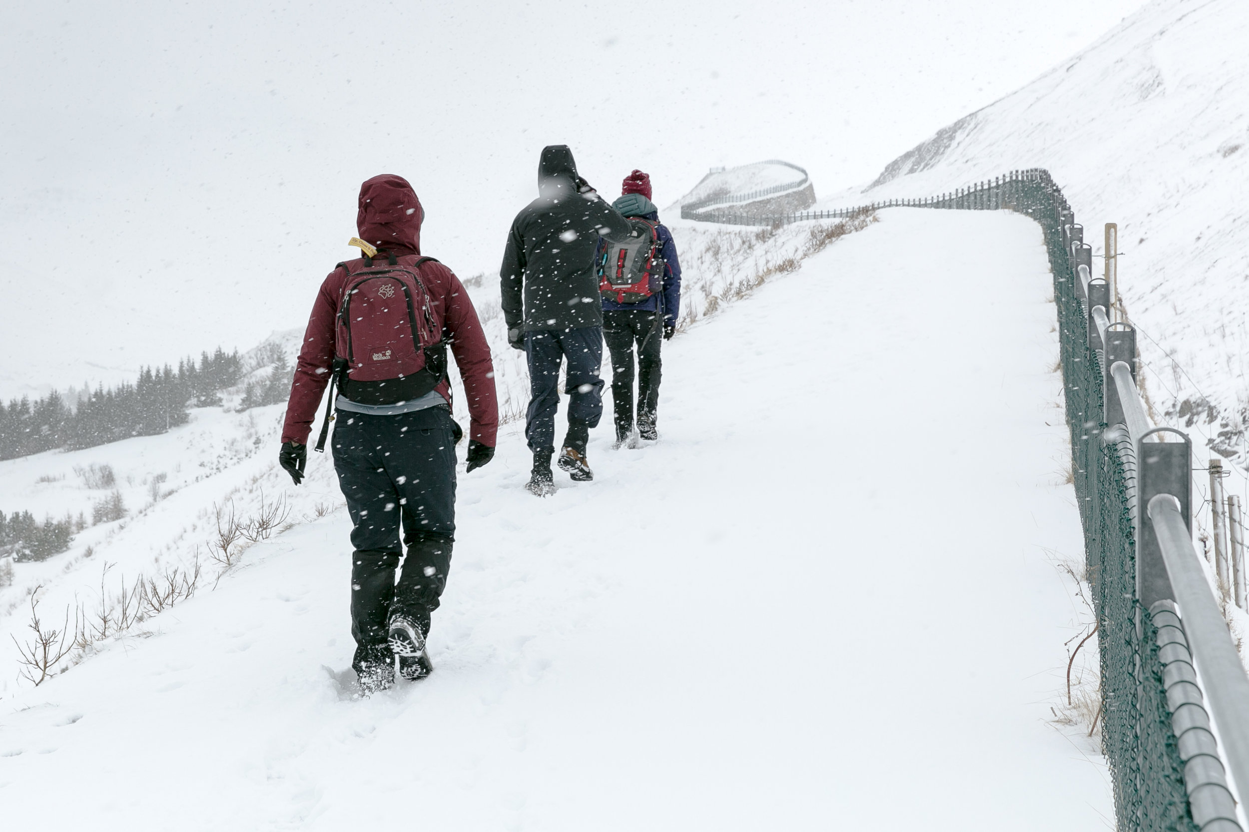
 

Hiking to the top. 

Panoramic of the top.
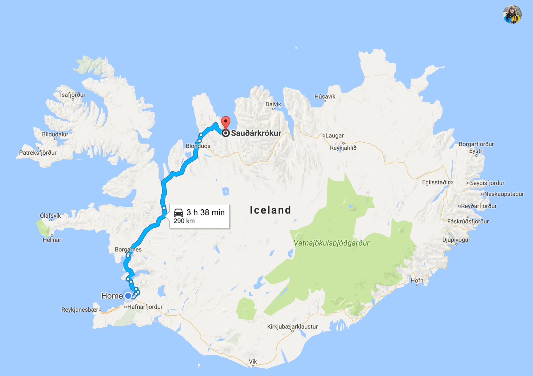
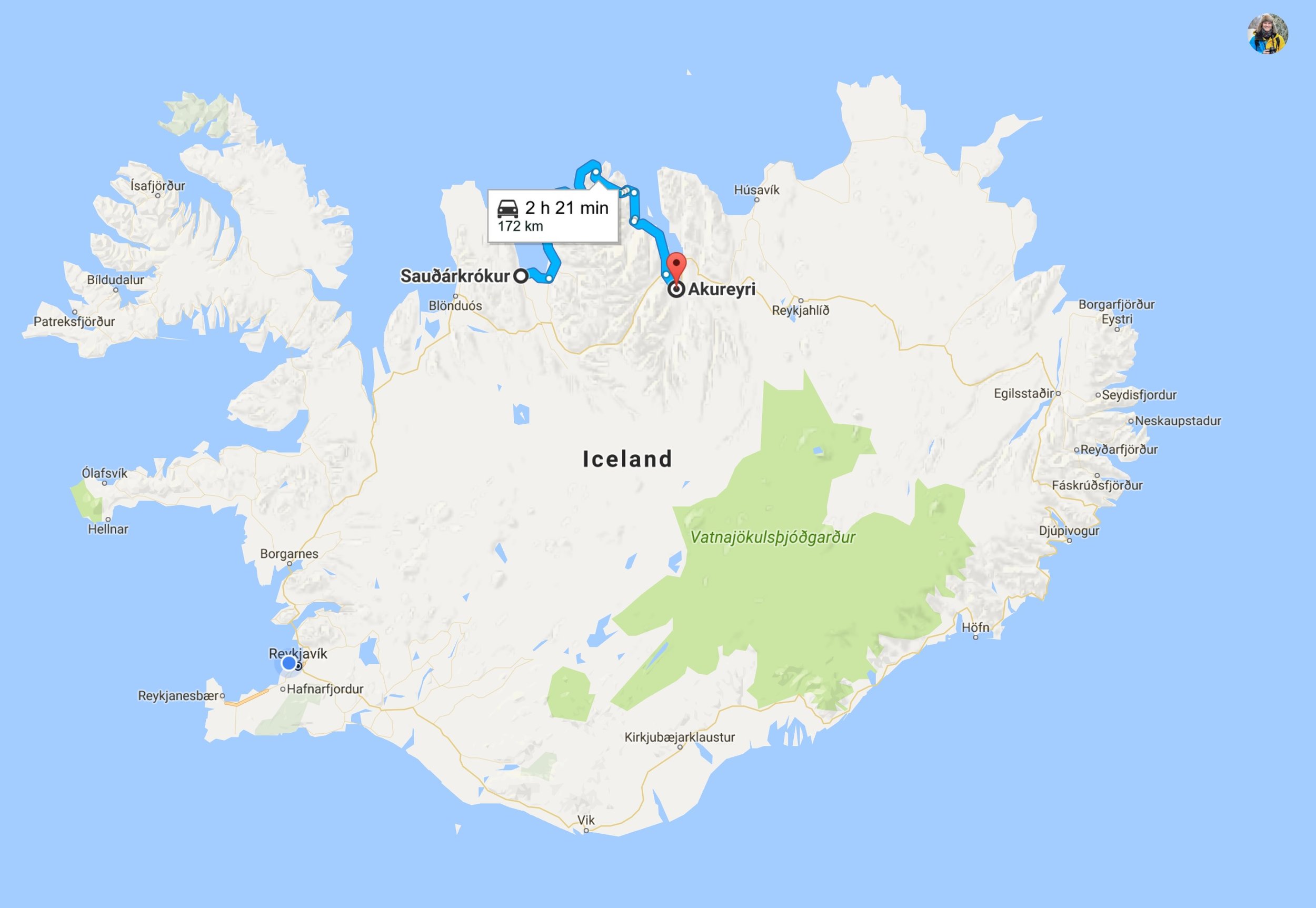
GPS route.

Playing in the snow.

Once we had finished the hike Scherie mentioned a waterfall close by that we had not yet seen, and you could walk behind it! So back into the cars for a short drive to see the waterfall. WOW! What an amazing place. 

Waterfall with Scherie.

Long exposure of the river Fossá. Click for a big version!

Aims behind the waterfall.

Well, as always, all good things must come to an end. We said are farewells and hit the road back to Reykjavik to start another week.

We will back to the Snæfellsnes Peninsula as it has so much to offer for so little travel time. But the next adventure awaits. We are off to the Westfjords of Iceland which is not on the normal tourist track of the well beaten route 1 circular. I can't wait! 

Thanks,

Kev

Find and follow me in Instagram 

The gang at the top of the hike. Left to right. Aimee, Scherie, Me, Cedric

Try saying this after a few beers...Snæfellsnes Peninsula. by Kevin Hatcher

It has been two weeks since my last post, as I have been very busy exploring the amazing landscapes of Iceland. Over the weekend of 5th May, friends and I traveled north from Reykjavik to explore the Snæfellsnes peninsula. The weather was AMAZING! Blue skies and sunshine. A great combination for a road trip adventure.

Driving up to the Snæfellsnes peninsula from Reykjavik.

Rauðamelsölkelda mineral spring.

It is about a two hour drive directly to our hostel at Grundarfjörður but we decided to stop on the way to find the Rauðamelsölkelda mineral spring. It is a short drive off the main road and down a dirt road, but well worth it.


Waterfall at Rauðamelsölkelda mineral spring.

Drinking from Rauðamelsölkelda mineral spring. Tasty.

Photo by: Mike Guarino Photography.

The spring is just to the right of the waterfall, and is like drinking fizz water. On the way out, or on the way in, you pass the Gerðuberg Cliffs. These cliffs are very prominent and distinct, and you can get right up close to them, even on top to get great views.

Approaching the Gerðuberg Cliffs.

Sitting on the Gerðuberg Cliffs.

Photo by: Mike Guarino Photography.

We drove up and over the peninsula in the glorious sunshine and bright blue skies. It was beautiful and arrived at Grundarfjörður. It was so nice that we decided to hike the famous and most photographed mountain in Iceland. Kirkjufell mountain..

The mountain rises up from sea level and has no direct trail to the top.  This trail is not for the faint-hearted and I would only ever attempt this when the weather is good and the conditions are dry. We got lost at one point and I ended up on a knife edge of a cliff looking directly at a seagull on its nest. Oops!

Kirkjufell mountain GPS route.

Kirkjufell mountain elevation profile.

Hiking up Kirkjufellmountain.

There are three sets of ropes to climb over areas that are very steep, including the last rope at the top which is very exposed. You really need a head for heights for this hike.

Cimbing the last rope before the top.

View from the top of Kirkjufellmountain.

If you do make it to the top the views are out of this world, especially on a day like we managed to get. There was not a cloud in the sky!

On top on Kirkjufell mountain.

Once we completed the hike we went to stay at the clean and well kept hostel at Grundarfjörður.

Grundarfjörður Hostel.

I did spend sometime taking a few images of the famous Kirkjufell mountain in the evening, but the real treat was in the morning. I awoke, or to be precise, I didn't sleep very well as I was not sure if I should get up early but eventually got out of bed at 6:30am and went to see the amazing morning light.  Below is one of the many images I created and is now on my website here.

Kirkjufell mountain with Kirkjufellsfoss in the foreground.

After being up so early I had the whole day in front of me, so went for a small walk just north east of Grundarfjörður up Eyrarhyrna. We then headed east to Ólafsvík for some ice cream in the sun. The route home would take us up and over the peninsula and once over onto the south side it was very foggy, grey and cloudy. I think we got a lucky break with the weather, as the mountains along peninsula seemed to be holding back the bad weather. 

Driving around the Snæfellsnes peninsula and back to Reykjavik.

What an amazing weekend with some great weather and some amazing hiking. I will be back to visit the peninsula as I never made it to the end, or hiked the Snæfell mountain. 

I hope you all enjoyed this blog and there is still my week adventure to the glacier lagoon at Jökulsárlón, and some crazy weather. Iceland is an amazing place.

Thanks,

Kev

Find and follow me Instagram.

P.S.

Although the weather on the way home was not as sunny and bright as it had been on the way up, we did manage to locate one of Iceland's little gems of a hot pool...Landbrotalaug. This is only big enough for four people and we were lucky as there was no one there when we arrived. Perfect.

Landbrotalaug Hot Pool

Landbrotalaug Hot Pool

Hiking in the wild. by Kevin Hatcher

The weather in Iceland for the last week has been wet! I mean it has been raining for days! No fun! Now I don't mind hiking in the "weather" but not when it is pouring down with rain to begin with. That being said I have managed to get out and try to take some pictures, it is just the light doesn't always cooperate. 

Hike 1 - Hvalvatn lake. 

I have hiked towards this lake twice now via a Western approach trail to Gymur falls, but have never quite made it to the Hvalvatn lake or the summit of Hvalfell. This time I wanted to try and catch the sunset over Hvalvatn, and approached the lake from the West. I drove up as far as I could in my Skoda Octavia 4X4 estate, before the "roads" turned into a serious 4X4 track only, and hiked the rest.   

Road Warning to adventure!

Road Warning to adventure!

Start of Hvalvatn hike.

Hvalvatn GPS Route.

I started at 5:00pm and the sunset was about 9:45pm, and I had a long way to go. The weather started with hail and wind, and thankfully eased off. It never really cleared however it did provide me with some amazing images of the snowy hills against the storm filled clouds. (New website Image!)

Unfortunately, I never made it to the lake, as the light was not in my favour and it was getting late. I reluctantly headed back, and as you can see from the GPS route below I still had a long way to go. The elusive Hvalvatn lake and Hvalfell will have to wait for another day.

Lesson learned today, always give yourself more time than you think.

Hvalvatn GPS Route

Hike 2 - Pverfell.

Fast forward a few days and the sun is splitting the sky in Reykjavik, so I am up and out to see if I can go further into the wilds. Travelling just under an hour and half to hike Pverfell, and see if I could take a few images of the lake behind it. The greatest and worst thing about Iceland is the weather. I had only just left Reykjavik and it started raining, but I pushed on. 

Pverfell hike location.

Pverfell GPS route.

As you can see, a short route, but it was nice to be away on my own in the wilderness.

Reyðarvatn Lake.

The light and weather seemed to be against me again, as when I reached the summit the clouds came in and engulfed me in fog. So no view today, but it was great to get more experience hiking in Iceland. 

Hugging the cairn at the top of Pverfell.

What a great few days hiking and there is still so much more to see! 

This weekend I am going to the Snæfellsnes peninsula and the famous Kirkjufell mountain and then next week down South East to Jökulsárlón to see the glacier lagoon and do some hiking in the Vatnajökull national park!

I can't wait, but the blog may have to wait until I get back.

Onward to the summer and camping in the wild. 

Cheers

Kev 

If you can't wait until the next blog find me and follow me on Instagram 

Hiking in the snow in Iceland. by Kevin Hatcher

The route from the car park and back.

Last weekend, Aimee and I went hiking up a mountain called Móskarðshnjúkar. It is a height of 807m (2647ft) and is a simply 9.2 kilometer (5.7 mile) there and back trip. It is only 20 minutes’ drive from Reykjavik, but it is well worth it as you feel like you are miles away from anybody.


Móskarðshnjúkar. It is the furthest right in this picture.

Móskarðshnjúkar is still very much covered in snow and we were the first people to hike it since the last snowfall. This meant that we post holed across the higher sections of the mountain, in our crampons and with our ice axes out. It was wild and very windy but what a great view! 

Aimee hiking in the snow.

Me hiking in the snow.

Aimee on the last push to the top with Reykjavik in the background and Esja. 

The view from top was spectacular, and we had not met anyone all day. This was until the summit where we bumped into a pair of hikers who had skis! They proceeded to pick a line down in the fresh snow and ski down. Very cool, and the best way to get down! I think I need a split board and bindings.

Fresh tracks from the summit.

Unfortunately, we didn't stay on the summit for long due to the biting cold wind and the weather on the horizon looked like they it might close in from the north. Still we headed down very happy with our accomplishment and stopped further down for lunch overlooking Esja and Reykjavik.

Esja on the right and Rejkjavik in the background.

What a great days hike and with fantastic weather. I am looking forward to more of this in the future.

But, maybe I should buy a splitboard and skins to make the return journey more interesting.

Kev

Remember you can also follow me on Instagram.

Me, on the saddle just before the top of Móskarðshnjúkar

Snow, hot pools, hiking and fjords. by Kevin Hatcher

I am falling in love with Iceland! WOW! What an amazing place, if you can get past the wind, rain, snow, and cold...that usually happens all in one day.

If I am honest, I like "weather" and I like that you have to work with the elements to explore. It goves you an enoumours sense of achievement. 

Easter weekend in northern Iceland. 

Day 1 - Reykjavik to Skagafjörður.

Standing in the wind on top of the Grábrók Crater...Just.

Standing in the wind on top of the Grábrók Crater...Just.

The drive up to Skagafjörður was a few hours but we broke up the driving with a few stops. Just north of Borgarnes there is a crater at Grábrók, which is a short walk around an old extinct crater. Great place, but very, very windy! 

As the drive continued I had to stop to admire a snowy pass when the sun came out with amazing blue skies. The whole scene  just glowed in the evening sun! Truly beautiful.

Snowy Pass.

Hot pool at Grettislaug. Thank you Aoife M for the image. 

Hot pool at Grettislaug. 

Thank you Aoife M for the image. 

The last planned stop before the end of day was in Grettislaug hot pot. This is a short drive off the main road about 20km down a gravel track. At the end of the track there are two small hot pot/pools, and a cafe. Relaxing in this quiet pool with the occasional dip into the icy cold sea was idyllic.

But sadly, all too brief, as the sun was setting and our hostel, Mirco Bar and Bed was waiting. Skagafjörður is not far and after dinner and a few very good craft beers, it was time for bed. 


Day 2 - Skagafjörður to Akureyri.

Next day we were up early from the hostel and out along the Tröllaskagi (Troll Peninsula). This area is the most northerly I have ever been. But we did manage to get a great view for lunch, and what a view! Next stop was Siglufjörður, which is a small town that would provide us with a small hike in the snow and the best Swiss Moca ever! Yum!

Siglufjörður in the snow.

Hiking in the snow on the avalanche barrier.

Hiking in the snow on the avalanche barrier.

Then it was onto our final destination...Akureyri.

Day 3 - Lava fields, Grjótagjá cave and hot pool.

Guess what, back into the car we go! Today it is off to walk across an old lava field and up a crater, followed by a dip in the Myvatn Nature Baths. Not to shabby for a day when the light was grey and the temperatures where cold! Brrr! 

Grjótagjá cave.

Hverfall Crater and lava fields.

Oh OK...we also stopped at Goðafoss waterfall, which is amazing! You get so close and you get a real sense of water flow. I will have to come back to get a better image of this iconic waterfall.

Goðafoss, Iceland.

Day 4 - Mt Súlur Hike.

Hike up Mt  Súlur.

Hike up Mt  Súlur.

Wakey, wakey time for hike. Blue skies and sunshine and fresh snow, what a great day for it too! 

The chosen hill was Mt Súlur, just behind Akureyri. It took 6 hours to do the round trip, with most of it post holing all the way up. But the views on the way up where amazing, with fresh snow, and bright sunshine.

Hike up Mt  Súlur. The bright one on the right.

Hike up Mt  Súlur. The bright one on the right.

Top of Mt Súlur

Top of Mt Súlur

Sadly no view from the top but well worth the hike.


Day 5 - Akureyri to Reykjavik.

Like all good things, they must come to an end. We left Akureyri for the long four and half hour drive home. We did stop at one of the last surviving turf roof churches in Iceland where we met a new friend.

Víðimýrarkirkja Turf Church.

Aoife and the cat.

Lights, camera, action.

A great few days away, with some great stops. I will have to go back up north and try and get some more images with better light. Unfortunately the "weather" was not quite as sunny and bright as I had hoped, but that means I will just have to go back!

Not a bad thing in the least.

The gang of adventurers on top of Hverfall Crater.

Aoife, Aimee, Me, and Tim in the background (he is having fun...honest!)

Well, I hope you enjoyed the pictures and stories, until the next time.

Kev

Follow more live updates on my Instagram feed.

Easter adventures. by Kevin Hatcher

Well, that is school finished! I was learning beginner Icelandic for 4 weeks, and now it is all over. What a great few weeks and I got to meet some amazing people from all over the world! 

Icelandic Diploma

Icelandic Diploma

Now the long Easter weekend approaches and I am heading away to get some images from the fjords and mountains of northern Iceland. First leg will be up to Sauðárkrókur which is a little under 4hrs of driving to stay at an Airbnb. 

Day 1 - Travelling to Sauðárkrókur

Day 1 - Travelling to Sauðárkrókur

The next morning it will be up to Akureyri via the Tröllaskagi (Troll peninsula) to stay for the next few days before the long drive back on Monday.

Day 2 - Travelling to Akureyri

Day 2 - Travelling to Akureyri

I am hoping to get some good weather and early morning sunrises, with maybe a waterfall or two thrown in for good measure. Fingers crossed the weather will be clear, cold and sunny. 

Below is an image I took last weekend when doing a small hike up Helgafell, which is just outside Reykjavik. The landscape here changes so dramatically and so quickly, it is awe inspiring! 

Helgafell and lave flow, Iceland.

Click the image for a full screen image.

Airplanes and black beaches in the dark. by Kevin Hatcher

How do you top the Northern lights? It is very difficult and unfortunately conditions have not been right to see them again since. The skies have been cloudy and the Northern light activity has been low, so no more Northern lights at the moment. However...

Skógafoss and the iconic airplane at Sólheimasandur

Map and directions to Skogafoss and the abbanonded airplane site

Map and directions to Skogafoss and the abbanonded airplane site

Time for another long drive to visit the Skógafoss waterfall and the abandoned plane wreck. The waterfall is about two and half hours drive from Reykjavik and is Iceland's biggest waterfall. The waterfall is very impressive but is also very busy with tourists. It was around 6pm at this point and is the highlight of any visit to Iceland and so it is to be expected.

Skógafoss from the river bed, Iceland.

Skógafoss from the river bed, Iceland.

Skógafoss from the viewing platform, Iceland.

Skógafoss from the viewing platform, Iceland.

After a few pictures, from the bottom of the waterfall I walked up to the top where there is a viewing platform. It gives you a real birds eye view of the falls and how big they really are. 

Time was marching on, so it was onto the main event!


A five-minute drive from the waterfall is the car park for the abandoned airplane site and the main reason for this particular trip. The site was accessed via driving in a 4x4 down to the crash site, but tourists kept driving off trail and getting stuck which left unsightly tracks on the black beach.  There is now a car park next to the main road and a 2.5 mile walk down to the site.

Looking back up the long walk back to the car park. Iceland.

Click the image for a full screen image.

I was packed with my camera gear, GPS tracker, and a head lamp as I wanted to get the sunset, and knew I would be walking back in the dark. It was a longer walk than expected or even noted in any online resource that I could find, but it was worth it. The skies where very cloudy and it didn't look like I would get any sunset or natural light, but I was wrong. Just as I arrived the sun burst out from under the clouds and gave me and a few others a brief window of amazing light to take a few pictures. I managed to get a couple of pictures.  

The picture below and the latest picture on my site.

Sunset over the abandoned plane on Slheimasandur. Iceland.

Click the image for a full screen image.

WOW! What a cool place! Worth the walk down there, but if you do go make sure you can get back. I had been tracking myself on a GPS app, and once the sun had set it was pitch black. The plane is in a dip or hollow, and the trail up to it ends above the edge of the hollow. This means that you can't really see the trail even when the sun is up. When I started walking back I initially did not use my GPS app and walked the wrong way. I couldn't find the trail. So I reached for my GPS app and found the trail again, and walked back in the dark with my head lamp. A few others did not do this and I saw them walking around the beach area trying to find the trail. They did eventually follow my light and find the trail, but if I had not been there it would have been a much longer evening for them.

What a great place. I will return if only to get some better pictures of the waterfall, and hike into the mountains! 

See ya,

Kev

Oh, and remember to find me and follow me on Instagram too!  

Norðurljósunum - Northern lights in Icelandic. by Kevin Hatcher

I don't intend to blog every day, rather about once a week, or when there is something interesting to tell you about.

So what have we here? Norðurljósunum or Northern lights. 

From my Instagram account. Kevhatcher

From my Instagram account. Kevhatcher

Last Monday night (27th March 2017) the forecast for the cloud cover over Reykjavík was clear, and the forecast for the Northern lights activity was very high. All of this information regarding the weather and the Northern lights activity can be found on the Icelandic Vedur site. 

So, as you can imagine, I was eager to see this natural phenomenon, especially as I have never seen it before. Shock! Horror!  

I packed up my trusty Canon 5D MKIII, a tripod, remote shutter and a series of lenses and then drove out to þingvellir national park. The park is approximately forty five minutes drive north east from Reykjavík, and is the easiest way to see the Northern lights. The Aurora can be seen from Reykjavík on a really good night, but getting away from bright city lights will improve the chances of seeing them in all their glory. 

I arrived at the car park close to the Öxarárfoss (Öxarár is a name of a river and foss is Icelandic for waterfall) and settled into watch the lights.

It was amazing to say the least! At one point it felt like I could actually reach up and touch the eerie green glow of the Northern lights, as they seemed to descend right down on top of me. 

Northern lights. March 2017

(Click the image and it will become full screen)

I had not planned an ideal location to take pictures, so I will have to go out again with a little more planning, but I did capture a few good pictures from just standing in a car park with my tripod and camera. 

Dancing Northern lights. March 2017

(Click the image and it will become full screen)

In the future, I will have to try and hike into the back country with a tent and stay overnight to get some better pictures. This will require the right conditions, with clear skies and a high activity Aurora...this could be very soon. Fingers crossed.

I hope you enjoy these pictures and the latest picture on my website. Feel free to leave any comments below and share this page.

Thanks,

Kev

Also available on Instagram