Weather

The secret blue river. by Kevin Hatcher

What an amazing few weeks I have had! I am only just sitting down now to process all of the images and try and catch up on my blog. 

Where to start...

This overnight stay happened at the end of May, and was a result of me getting itchy feet to go out on my own to take some images. 

Now, the location I had in mind was a foss (Waterfall in Icelandic) called Brúarfoss and it is about 2hrs drive from Reykjavik. It is a great little place that seems to be causing a bit of a friction with the local Icelandic population. After visiting the area and adding to the issue I can totally understand why, so I am not going to locate the foss here, but if you are keen to see it there is enough information on line to locate it.  The area is a "Private" summer house retreat for the locals and with the increase of tourists and lack of infrastructure the road and trails are over used. 

I left mid afternoon from Reykjavik with the sun shining, clear beautiful blue skies, and great big white fluffy clouds in the sky. Perfect! After eventually finding the area, and a place to park I walked off along the very beaten up and muddy track to be rewarded with an amazing river scene. I spent the afternoon there to find a good composition in relation to the sunset. This would mean that when I returned later that evening I would have a picture already in my minds eye and could set up my camera quickly.

Brúarfoss during the day.

I drove down the road a few kilometers to a campsite next to the geysir field. This geysir field is on the golden circle route and is very popular with the bus tours, which makes it very popular during the mid morning and late afternoon.

Camp site for the tent.

Fortunately, I was spending the night there, so after dinner I went for a walk around the geysir field and almost had the place to myself in the evening sun. The Strokkur Geysir erupts every 5-10 minutes so you are bound to see it, and then you can walk around the area looking at the other less active hot pools. What a great place. 

The Strokkur Geysir can reach as high as 70-80m

After my walk around the geothermal springs I headed back to the car to set off back to Brúarfoss for the sunset.  I arrived and walked down to the river and had the place to myself. Unfortunately the clouds started to roll in and I maybe should have been there about an hour earlier to get some nice close up images of the waterfall. I will also need to bring wellington boots next time, as there is far too much water for my hiking boots to stand in the river.

I did manage to get a few shots that I am very happy about and they are on my website just before the sunset was completely obscured by the clouds and mountains.

After the last light disappeared I headed home at about midnight. I returned to the campsite and went to the car to get my sleeping equipment, but I could not find my sleeping bag! Oops! I made do with putting all my clothes on and got some sleep in the tent. Needless to say it was cold that night. 

The next day it was grey, rainy and cold, so I decided to head back home and get ready for my next adventure...The amazing Westfjords. New blog coming soon!

Thanks


Kev

Find and follow my stories on Instagram too!
Long drive, ice diamonds, and closing roads. by Kevin Hatcher

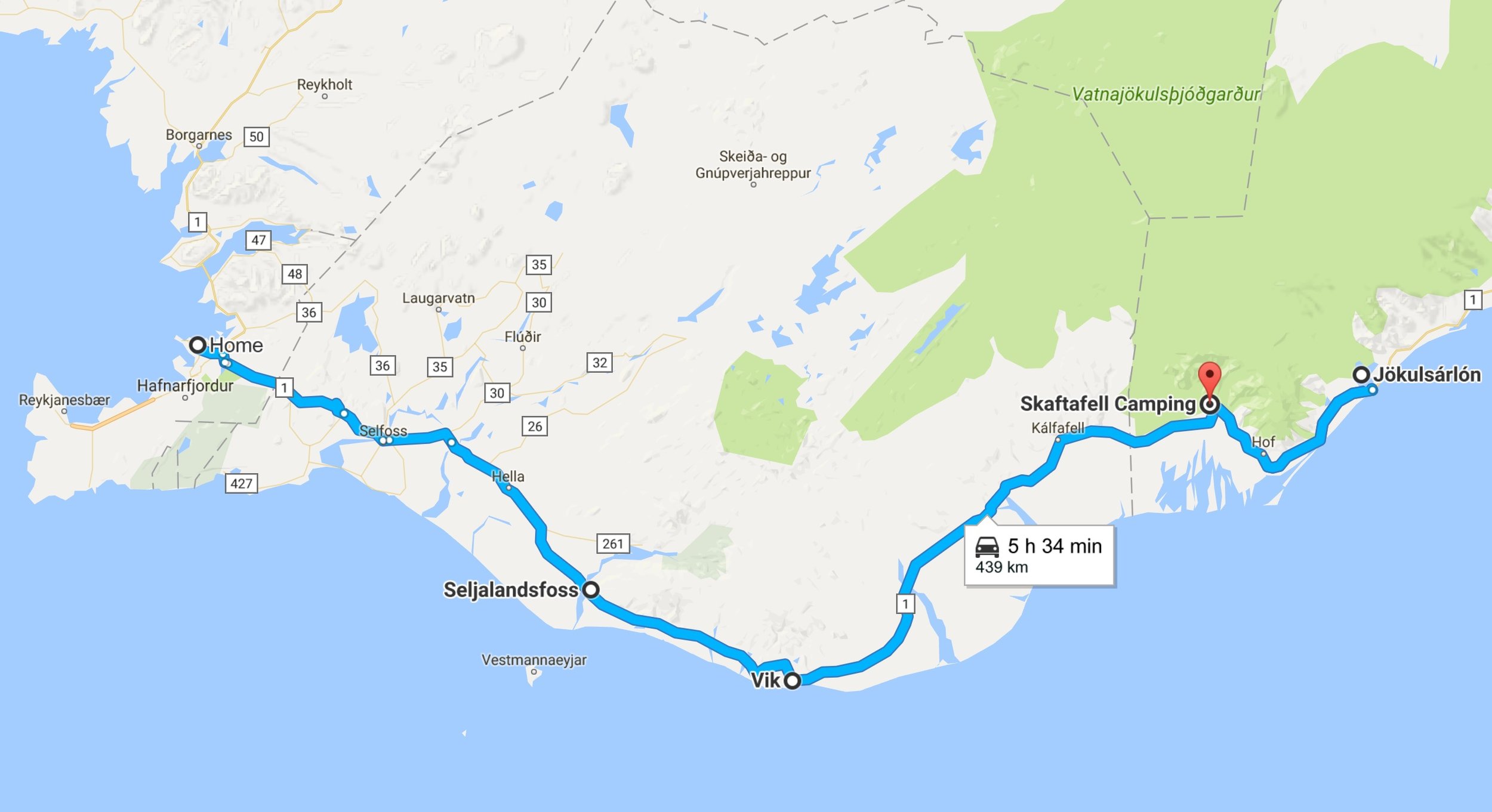
What a great weekend at the Snæfellsnes peninsula, with some of the best weather I have experienced in Iceland. The only thing better than coming home from a great adventure is to repack and head out on the road again to go on another. So... I packed the car with a good friend of mine Mike Guarino from Mike Gaurino Photography to start the long drive south east to Skaftafell National park in Iceland and Jökulsárlón to do some backpacking, hiking and photography.  

Reykjavik to Skaftafell National park (4 Hours 1 minutes) and then Jökulsárlón, glacier lagoon (40 minutes)

Reykjavik to Skaftafell National park (4 Hours 1 minutes) and then Jökulsárlón, glacier lagoon (40 minutes)

Now, the Icelandic tourist board does an amazing job of advertising the sites of Iceland, but what they don't tell you is:
1.    Iceland is bigger than it looks!
2.    All of the tourist spots are scattered all around the coast just off Route 1. The only "main" road around the country.
3.    The weather in Iceland can change in an instant from amazing too crazy very quickly. To be fair to the tourist board they do warn tourists and visitors about the weather and all the information is on the Vedur site and app (www.vedur.is) and road information site (www.road.is).
I checked the weather on Monday, the night before we had planned to leave, and it looked OK, cloudy and then changing to showers by the end of the week. I double checked the weather on Tuesday morning and it was very different, cloudy and overcast for the drive, then rain and gales for the day after we got there. Hmm, what to do? A long drive to see some cool Icelandic sites and hope the weather changes again or stay home? 
Adventure waits for no-one! Into the car on Tuesday morning with all the backpacking and camera gear.
First stop on the way was Seljalandsfoss. A very impressive and big waterfall that is located just next to route 1, so it is a tourist hot spot. 
 

Seljalandsfoss with a random tourist for scale...it's a big waterfall and you can walk behind it too! 

Mike Guarino at Seljalandsfoss.

Behind Seljalandsfoss.

A great place to stop, but it can be very busy, so pick your time. But the national park awaits so, back into the car and onward to Vík í Mýrdal for a quick lunch stop overlooking the black sands beach.

After a long drive across some amazingly barren and open lava fields we finally arrived at Skaftafell national park around 4pm.

As we crossed towards the campsite this is the view north to Skeiðarárjökull Glacier.

We had planned to stay in the park campsite on Tuesday night, but the weather up to this point had been pretty good, so we thought maybe we could backpack into the national park and stay at the base of Morsárjökull Glacier (shown below center top of the map). Unfortunately, it is not possible to wild camp in the national parks here in Iceland, so we set up camp in the campsite. 

Skatafell Map

Once set up we walked to see the Skaftafellsjökull glacier, which was an amazing sight and my first up close look at a glacier. The light was pretty flat because it was late afternoon and cloudy, but still an impressive site.

Skaftafellsjökull Glacier.

Kevin Hatcher taking pictures of the glacier. Thanks Mike.

It was pretty busy with tourists because it is very accessible and about a 20min walk from the main entrance and campground.

Tourists at Skaftafellsjökull Glacier.

We returned from the short walk to see the glacier, had some dinner and then decided to drive 40 minutes to Jökulsárlón to see the glacier lagoon. The weather was beginning to turn and the clouds were grey and dark. The drive there was difficult due to the heavy rain showers and side winds, but we made it and WOW! it was so worth it!

When you arrive there is a car park on the north side of the road that you can park at and then walk to the lagoon, and see the large junks of ice floating down to the sea. The lagoon has a wide river running from it, with a bridge, but we never went over the bridge. We did go to the BEACH! Now that is breath taking. 

Imagine if you had the blackest sand and then scattered white and crystal clear diamonds all over it, then you get close to what this beach looks like.

Jökulsárlón Glacier Beach.

It was amazing, and Mike and I spent the next 2-3 hours taking photographs and admiring the views. The only reason we stopped is because it got too dark, and it started to rain. But WOW! What a place.

Holding a ice diamond at the Jökulsárlón beach.

Long exposure Jökulsárlón beach.

I have so many images from this beach and its prize jewels I could fill a book. It is difficult to pick only a few images to share, but needless to say I will go back, and hopefully the weather will be better. Talking about the weather we returned to this sign...

Weather report for the national park area. FYI 20m/s = 44mph and 45m/s = 100mph

The plan in the morning was to go for a short hike to see the Svartifoss but after a discussion with the one and only employee who had made it to work, we decided against it. Why you ask? Well, we were informed that the roads home are to be closed at 11:00am, it was 10:30am. They also didn't know if or when the roads would reopen. So with heavy hearts we packed up and got back in the car and drove back. As we did the wind speed increased and sections of roads did close, it was great fun! 

Road closure information. 

Red roads = Closed.

We made it back to Reykjavik late that day after a very windy, wet and bluster drive, but what a drive. I will have to go back there as the scenery is spectacular, and one night is just not enough.

Getting far to dark for my selfie camera at Jökulsárlón beach.

I hope you enjoyed reading this as much as I enjoyed sharing it with you all. I have a few more things in the pipeline for the blog. I have last weekends adventure back to Snaefellsnes peninsula and I am going to get an RSS feed set up so if you want to keep up to date with the blog it will be delivered directly to your email box! How awesome is that. 

Stay tuned folks and follow me on Instagram for regular updates and images. 

Cheers

Kev

PS I hope this week will be double blog week!